MISSION 31AN
Las Vegas, United States
LANDSAT · DECLASSIFIED
Frame detail
MAG ×1.75 — 30 M GSDObservation
What the pass recorded.
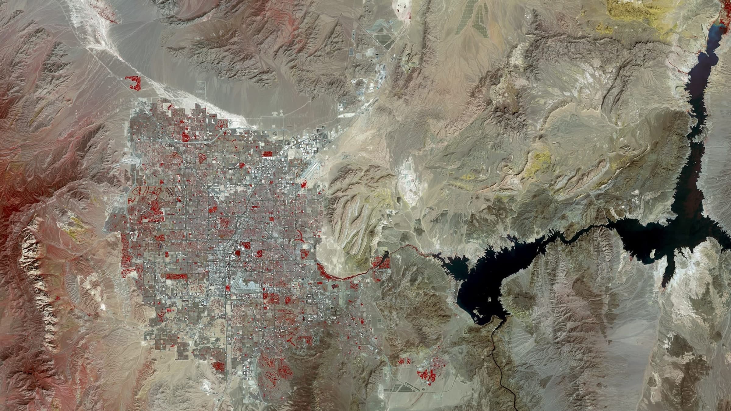
Las Vegas spread across the floor of the Mojave, the valley ending in a hard line where irrigated development meets bare desert. The Strip runs as a straight bright axis through the middle of the basin, and Lake Mead sits off the eastern edge of the built area.
Telemetry
As flown.
The pass that produced the frame above, as it was recorded: where the sensor was, what it was pointed at and what the sky was doing at the moment of capture.
- Coordinates
- 36.1699, -115.1398
- Position
- 36.17° N / 115.14° W
- City
- Las Vegas
- Admin area
- Nevada
- Country
- United States
- Captured
- 2023
- Sensor
- LANDSAT
- Altitude
- 705 km
- Ground sample
- 30 m
- Pass azimuth
- 101°
- Off-nadir
- 1.9°
- Cloud cover
- 0%
Composed by the same pipeline that produces the print file: the capture above, the mission sheet below. Shown watermarked, at preview resolution, in a display mount.
Deliverable
How it would be printed.
Standard issue. Street grid stays legible.
- Format
- 50 × 70 CM
- Imperial
- 20 × 28 IN
- Ratio
- 5:7
- Finish
- Framed
- Print facility
- US / RENO, NV
Source
This reference frame is a public-domain NASA / USGS Landsat product. It stands in for a customer capture, which is tasked commercially and delivered at higher resolution.
- Credit
- 50+ years of Landsat: Las Vegas
Tasked across commercial imaging constellations
- PLANET
- VANTOR
- SATELLOGIC
- ICEYE
- UMBRA
- GEOSAT
Set in type, not in marks. The operators above are constellations reachable through our tasking network; none of them is a partner of Shot from Space and none endorses it. Frames shown on this site are reference imagery for positioning, not operator captures — see the imagery credits.

End of file
This frame was already taken. The next one is tasked for you.
Give an address and a satellite is scheduled over it. The frame comes back composed with its own mission sheet, printed on the continent you live on and shipped as a finished object.
Start a missionMissions from €65 · Shipping and duties included · Full refund if no usable frame in 60 days